

Bengaluru's Traffic Gridlock: Data Points to an Uncomfortable Truth
Bengaluru's congestion is usually framed as roads vs public transport. Our analysis of road area per capita across Bengaluru, Delhi, and Singapore suggests the real problem is more fundamental: the city simply does not have enough road space.
Traffic of my city, Bengaluru, is legendary: for all the wrong reasons. WhatsApp groups need to be told to avoid this painful topic, even more than political ones. A journey of barely 4-5 km routinely takes an hour during peak periods, in certain parts of the town.
Every few months, a new idea is proposed to solve the problem: better traffic management, congestion pricing, work-from-home policies, AI-driven traffic signals (we aren't the tech capital of the country for nothing) or another phase of Namma Metro expansion. Last year, a founder of a Delhi-based company even announced a reward for anyone who could solve Bengaluru's traffic problem using traffic data (unclear, if anyone won this).
These initiatives may help at the margins. But they all assume that Bengaluru's congestion is primarily a traffic management problem. Our analysis suggests otherwise. The city's biggest problem is far more fundamental: Bengaluru simply does not have enough road space.
The debate over Bengaluru's congestion has largely been framed as roads vs public transport. One side argues that expanding Namma Metro, with feeder bus network, is the answer; the other believes the city needs more roads for increasing private vehicles. Surprisingly, however, very little publicly available data exists on the current state of road network, across cities. Without objective metrics, discussions tend to become ideological rather than evidence-based.
To fill that gap, my colleagues at Latlong analysed Bengaluru's road network and compared it with that of Delhi and a global city, Singapore.
Road length tells only half the story
A traditional metric used by urban planners is the relationship between a city's area and the total length of its road network. At first glance, Bengaluru does not appear to be lacking roads.
Bengaluru (Greater Bengaluru Authority – GBA) is a relatively small city, with a circular radius of about 16 kms. We compare Bengaluru primarily with Delhi NCT (Delhi), which is less infamous for traffic. Bengaluru is half the size of Delhi. Compared to Delhi, Bengaluru has marginally more road length, given the size of the city.
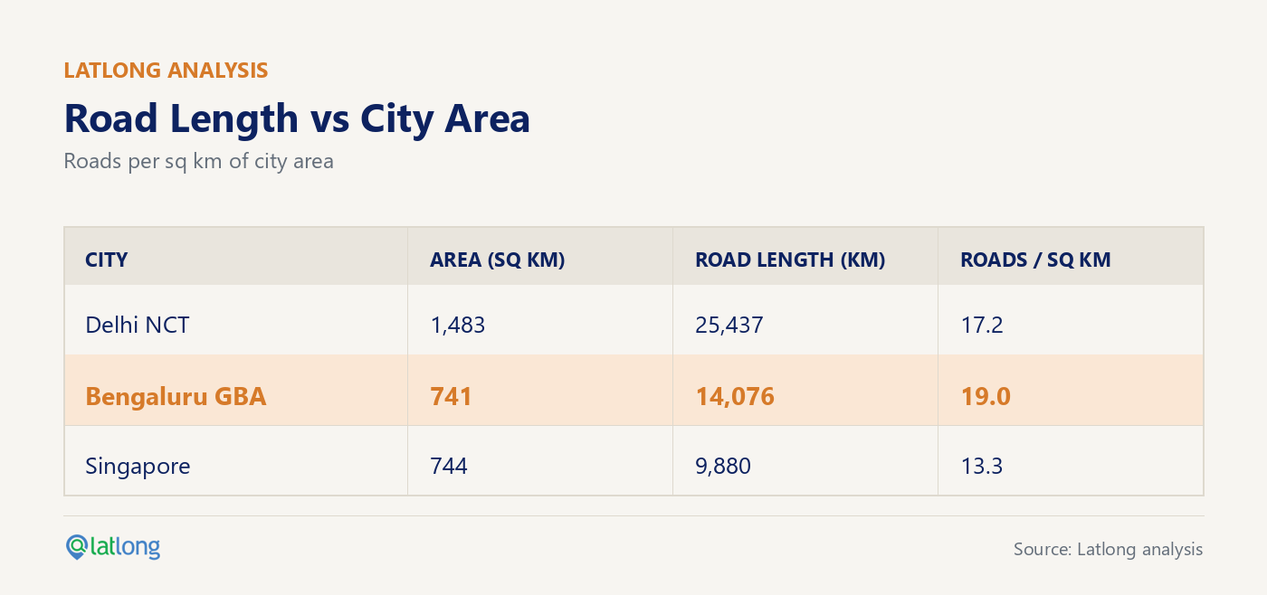
At first glance, these numbers suggest Bengaluru is relatively well served by roads. But this metric is misleading. A 10-metre-wide residential lane with parked cars is counted the same as a 50-metre-wide arterial road. Clearly, the traffic-carrying capacity of the two is vastly different. Road length alone, or even road length relative to city area, doesn't adequately describe a city's transport capacity.
Road Area is what matters
A more meaningful metric is road area: the length of a road multiplied by its width. Calculating road area is more complex because road widths vary significantly, even along the same road. This is particularly true in Bengaluru, whose road network evolved through the gradual incorporation of a multitude of villages into the ever-expanding city. We addressed this by using spatial queries for each individual road segment. This allows us to compare not only total road area, but also the share of city land devoted to roads and the average width of roads.
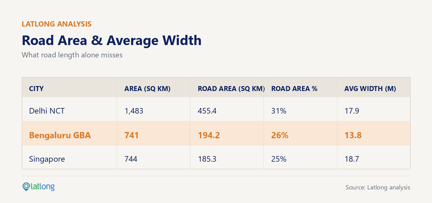
The difference is striking. Bengaluru dedicates a significantly smaller share of its land to roads than Delhi. More importantly, its average road width is just 13.8 metres: barely enough for two vehicles to pass comfortably in opposite directions, especially once on-street parking or other obstructions are taken into account. Delhi roads, on average, are 12 feet wider, which is a lot more room for vehicular movement. Notably, Singapore uses a similar available area for roads, but has much higher average width.
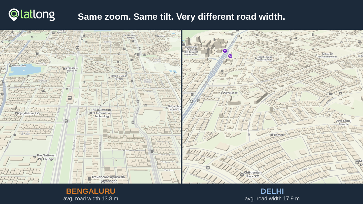
In the map below, Bengaluru's upscale Jayanagar / J P Nagar area is on the left, while Greater Kailash in Delhi is on the right. Both maps are at the same zoom level.
Shortage is starker when population is taken into account
Road capacity has to be viewed against demand: volume of traffic using the roads. Bengaluru has approximately 1.2-1.3 crore registered vehicles, including around 25 lakh cars. It is among India's more prosperous cities, with a per capita income approaching ₹8.6 lakh, as compared to Delhi with about ₹5.6 lakh. So, the number of vehicles (especially, cars and larger vehicles) is likely to continue growing.
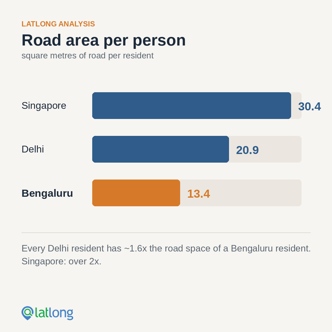
The Greater Bengaluru Authority (GBA) estimates the city's population at around 14 million, which is remarkably close to the total number of registered vehicles. Population therefore serves as a useful proxy when comparing road availability across cities. The resulting comparison is revealing:
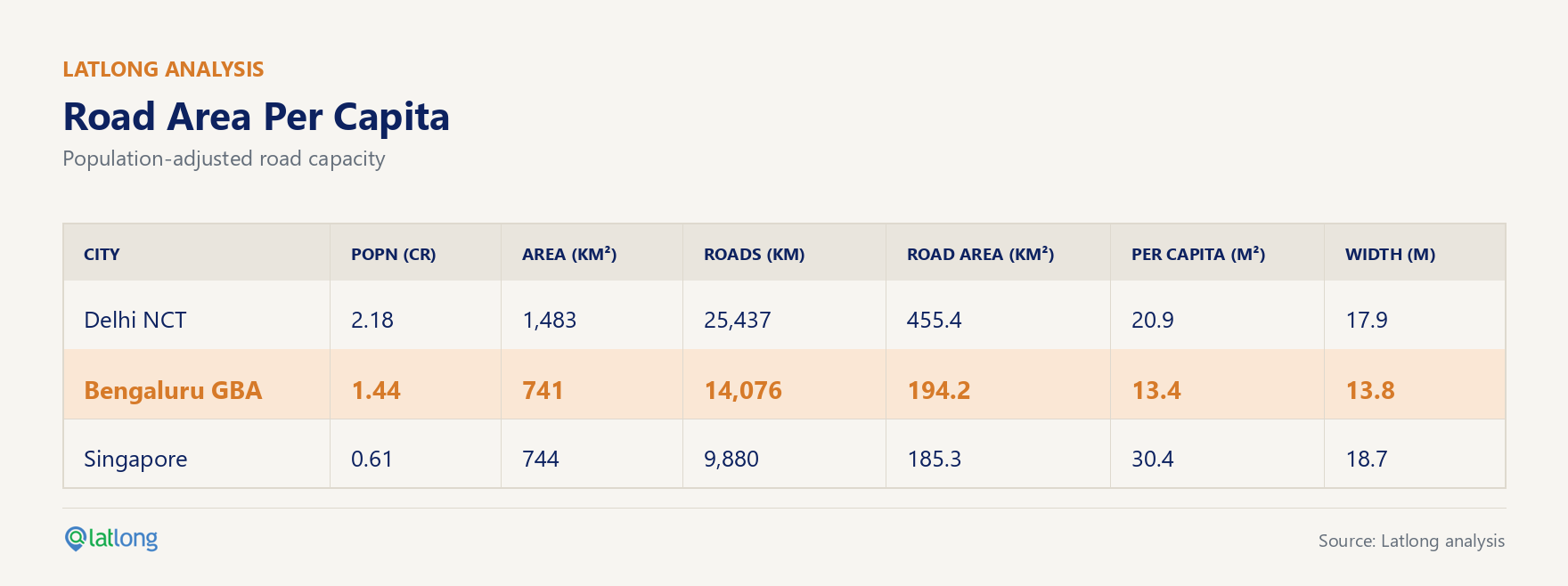
Every resident of Delhi effectively has access to ~1.6x as much road area as a resident of Bengaluru. A city-state like Singapore, which taxes private vehicle ownership quite heavily, has 2x+ the amount of road area available per capita. Quite clearly, the issue of gridlocks in Bengaluru is simply not a question of poor traffic management. It is a question of physical capacity.
No amount of signal optimisation or AI-based traffic control can permanently overcome a city-wide shortage of road space. Such interventions may improve traffic flow by a few percentage points, but they cannot create capacity where none exists.
Roads or metro: a false dichotomy
Public transport is essential and will undoubtedly reduce congestion. Continued expansion of the Namma Metro network should remain a priority. However, rising incomes also mean rising vehicle ownership. A relatively less affluent Delhi, with India's largest metro network, has 60% more road area per person compared to Bengaluru. This suggests that public transport alone cannot solve the city's congestion problem.
Bengaluru needs both: an extensive public transport network and significantly greater road capacity. That means completing long-delayed road projects, widening critical corridors where feasible, eliminating network bottlenecks, and building grade-separated infrastructure, whether elevated or underground, where demand justifies it.
A Practitioner's View
V Ravichandar, an urban expert and public policy specialist, notes: "Road density measures are 'road kms per square km of geographic area'. This can be erroneous unless we consider road area, implying importance to road widths. While most of us push for public transport usage, the extent of deficit in road area per capita, needs to be taken into account in our planning, as private vehicle ownership is also a reality. A mobility plan for Bengaluru must now treat uniform carriageway width as seriously as metro alignment, or the gridlocks aren't going away."
The city's traffic crisis is not merely a technology problem or a planning problem. It is fundamentally an infrastructure deficit. Until Bengaluru addresses that deficit, every new traffic management initiative will amount to little more than managing scarcity.
The analysis for this article has been done using Latlong Maps.
More posts

Sep 18, 2026
The Day a New Dealership Broke an Entire Sales Territory
Sep 11, 2026
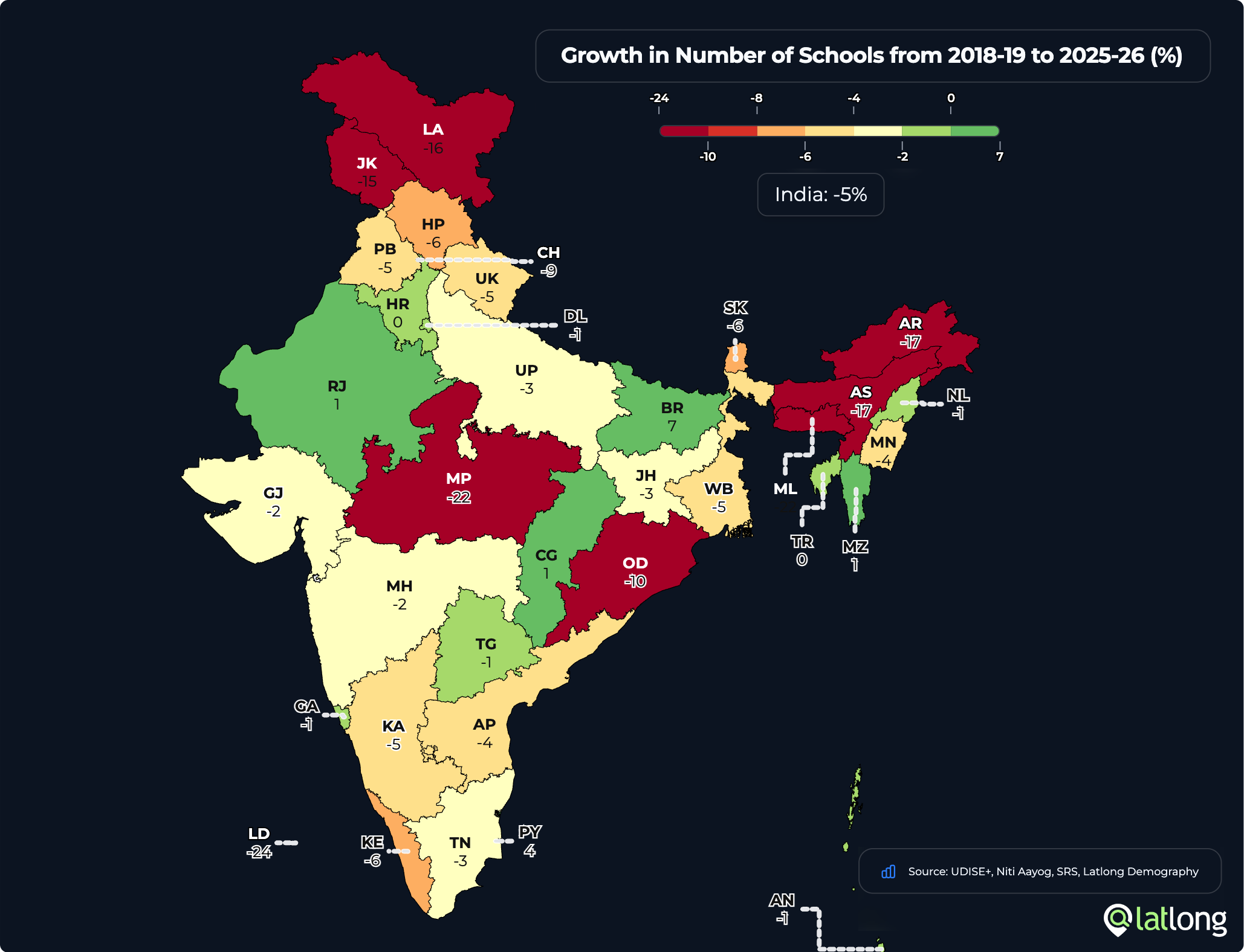
Schools, Enrolment and Teachers: There Aren't Enough Children
Aug 12, 2026
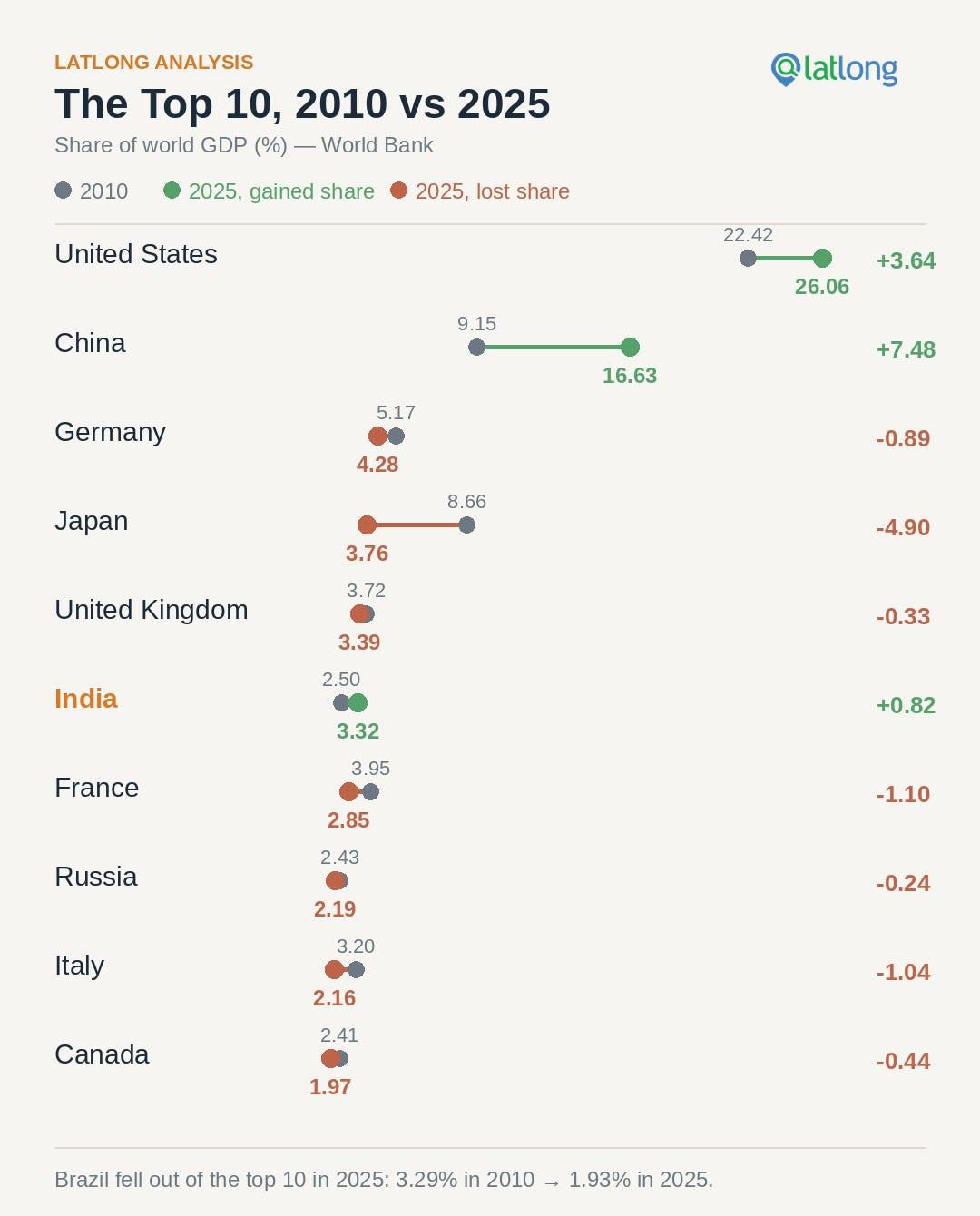
Growth of India's Share Of Global GDP in 15 Years: From 2.5% To 3.3%

Jul 27, 2026
Hyperlocal Location Identification: Why the 'Periphery' is the New Frontier for Business
Put location to work.
See how latlong.ai products fit your team. Book a 30-minute walkthrough with our solutions team.